
Curious that this isn't bigger news -- Australia's most iconic multi-day walking track, rapidly being burnt out. This was 11:00 am yesterday, just south of Cradle Mountain: https://browser.dataspace.copernicus.eu/?zoom=12&lat=-41.78821&lng=145.95577&themeId=DEFAULT-THEME&visualizationUrl=U2FsdGVkX1%2FDRRwvmuC7bl8Fi7ccwB3Su9OyC7KSYYbLDCqWWuv%2Fs3qg5ur7FKNgmmtf9rR5mbnAH7CVFO9piGP9eKdshOBtQU7EmMqcZk1dIX9fWlfhsZ5bpQivIt%2FP&datasetId=S2_L2A_CDAS&fromTime=2025-02-10T00%3A00%3A00.000Z&toTime=2025-02-10T23%3A59%3A59.999Z&layerId=4-FALSE-COLOR-URBAN&gain=1.3&demSource3D=%22MAPZEN%22&cloudCoverage=30&dateMode=SINGLE
Comments
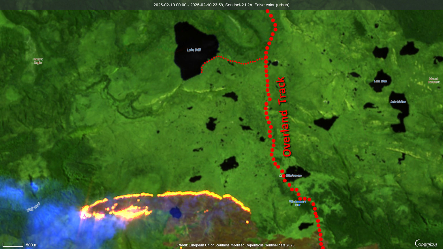
Sentinel-2 imagery, false colour urban – dark brown is the burnt area, flame colours show infrared hotspot detections:
https://bsky.app/profile/gergyl.bsky.social/post/3lhunoafg4s2g
The last time fire closed the track was the extensive Lake Mackenzie Road fire, to the east, in 2016.
(The limited fire detections visible here will be due to current cloud cover, not reduced fire extent. Detection satellites cannot see through cloud.)
https://firms.modaps.eosdis.nasa.gov/map/#t:tsd;d:7days,24hrs;l:fires_all,countries,landsat_human,protected_areas,earth;v:max;@145.96,-41.73,12.66z
(But the ABC News story is about beekeepers. No, seriously, it is: https://www.abc.net.au/news/2025-02-12/threat-to-bee-hives-bushfire-west-coast-tasmania/104927438.)
It's for this reason & others that I believe we need a paradigm change in firefighting to suit the climate-changed 21st C:
- use lge aerial attack to arrive quickly esp in remote & inaccessible areas. (Ground crews often take too long to arrive & fire has grown; less controllable).
- rappelling crews &/or buckets for areas w/ closed canopies (which reduce effect of direct o'head waterbombing).
- ground crews to finalise control & make 'safe'.
- use hand-held or aerial IR (as approp) to locate & black out hot spots.
But I think we're not selecting & using aircraft in an optimum way.
Stopping early wildfire DEVELOPMENT is the key to preventing large wildfires.