I’m just so frustrated with the know-nothing, anti-science crowd always using “cutting spending” as the only response to everything. The joke is on them; we’re all in this together. Woke is a badge of honor, IMO.
Ain’t that handy to have during a storm season? Guess we’re back to holding our wet finger in the air and trusting the chickens and other farm animals to warn us ahead of any bad weather.
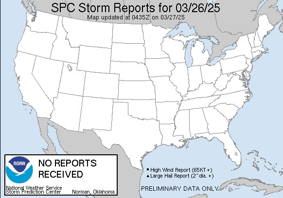
So very handy.
Who did this? Felon 47. Let everyone know.
There were widespread thunderstorms, and the language around the threat was for a low chance of some severe thunderstorms, which didn't happen. However, the conditions came close to it. So to me, it really wasn't a failed forecast as much as realizing the probabilities were low to begin with.
That’s a valid way to look at it, but still relatively large area with moderate (for any area) risk of severe weather. To not have a single storm report is a surprise to any forecaster especially considering the updraft helicity tracks and convective parameters being spit out by mesoscale models.
There was definitely some model hype out there on social media. However, the SPC and NWS were pretty consistent with a 10-15% chance of severe weather (e.g., hail >1.5"). That level of probability is not considered "moderate risk", but I agree with them that it was worth communicating as possible.
For those who deal with these things, it was not a surprise because the forecast was for a low probability event. That such an extreme event was possible (even remotely) was of interest. In any event, the probabilities are not such that 10-15% of a region will experience the event.
The forecast was for severe hail and there's not a single severe hail LSR. Lightning isn't considered severe weather. Reddit is full of posts mocking the failed forecast.
Too much cloud cover and the mesoscale models were off on dew points by almost 10 F. The HRRR backed off hard on CAPE today.
The forecast was for a slight chance of severe hail, not for a certainty. This is from the NWS Portland forecast discussion this morning. Again, the problem here is not understanding probabilistic forecasts.
The SPC uses terrible naming conventions, people out east are used to it but nobody who hasn't seen this stuff regularly should be expected to properly interpret "slight chance of severe weather meaning 15% chance of severe hail within a 25 mile radius".
People have different risk tolerances. It is not accurate to say that credible sources deemed the risk likely for today, only that it was possible. I am taking issue with the assertion that the forecast was a bust because the low probability extreme did not materialize.
I think what was most shocking to me is that, once convection got going, not a single updraft was able to maintain itself and intensify to even low-end severe. Thought upper divergence and steep mid-level lapse rates would help with that. LLJ I think was also late.
Wasn’t closely following the threat this evening and not really sure what went wrong, but assume there was some convective inhibition that wasn’t overcome and that instability was overmodeled at the low levels. Looked like a cap remained in place on 18z sounding was first sign of big failure mode.

Comments
So very handy.
Who did this? Felon 47. Let everyone know.
Too much cloud cover and the mesoscale models were off on dew points by almost 10 F. The HRRR backed off hard on CAPE today.
There should have been at least some LSRs.