
We use hi-res regional modelling to look at two atmospheric river cases (winter & summer).
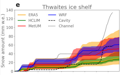
Observations are scarce in this region and we have obs of snowfall only over Thwaites (thanks to AMIGOS sensors). All models do well, and better than ERA5 ⬇️
This makes hi-res modelling essential!
2/8
Observations are scarce in this region and we have obs of snowfall only over Thwaites (thanks to AMIGOS sensors). All models do well, and better than ERA5 ⬇️
This makes hi-res modelling essential!
2/8
1 / 2

Comments
☔Rain is also falling at sub-zero temperatures over the ice shelves and even over the ice streams of Thwaites and Pine Island.
Rain (dark blue contours) falls above the melt line (dashed) in this figure, showing a transect through PIG.
3/8
Hi-res really helps here, and it's all we've got to go on because there are no observations of rainfall in this region - this really should change!
4/8
The slopes also drive warming near the surface, and ramp up the production of snow via a phenomenon called the seeder-feeder effect.
Fig from https://wasatchweatherweenies.blogspot.com/2020/04/the-seeder-feeder-effect.html
5/8
Watch here: ▶️ https://youtu.be/0-zLGu2t_e0
6/8
https://www.carbonbrief.org/guest-post-how-atmospheric-rivers-are-bringing-rain-to-west-antarctica
7/8
https://tc.copernicus.org/articles/19/597/2025/
HUGE thanks to my co-authors (the only one on Bsky is @michelle-maclennan.bsky.social ) and to @polarres.bsky.social for funding the work.
8/8