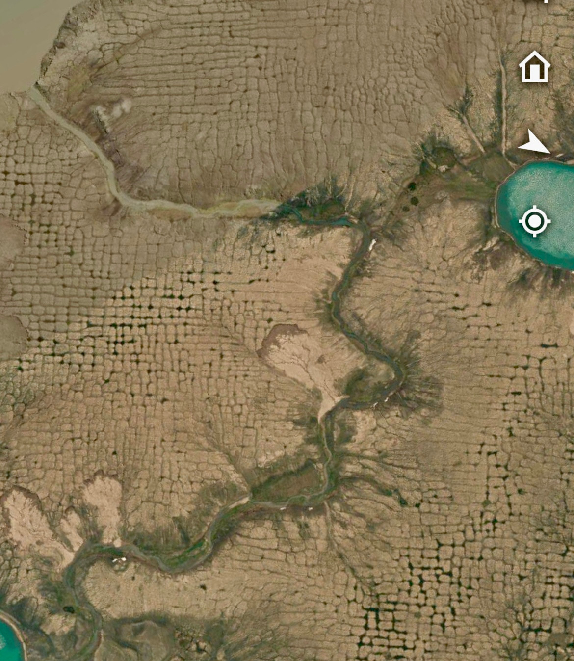
I will never get sick of looking at these kinds of permafrost landscapes. Amazingly orthogonal ice-wedge polygon networks and retrogressive thaw slumps on Banks Island, NWT, Canada.
Comments
Log in with your Bluesky account to leave a comment
There are thousands of retrogressive thaw slumps on the moraine system on Banks Island because it’s full of relict glacial ice that was buried by sediment and preserved in the permafrost after deglaciation.
Yes! Recently thaw has penetrated into the tops of the ice wedges and satellite imagery trend analyses by Rob Fraser at NRCan show increasing ponding in the ice wedge troughs on flat terrain across Banks Island and other islands in the Canadian Arctic Archipelago.
Nice!!! They are so fractal, if you compare them to these in the field in #Iceland. Shows the same patterns at slopes, where the turn to near parallel lines in stead of hexagons
can you tell me more about traversing such landscapes? Is it walkable? can jeeps drive over it? how do animals fare? As large-scale melting of the permafrost seems inevitable, will we see any large-scale patterns like this?
It is walkable but the ponds you see in the troughs can be significant obstacles. You would not be allowed to drive over this landscape, as this would disturb the ground further and initiate enhanced permafrost thaw. Also it’s very far from nearest community (Sachs Harbour)
In general, increased ponding and wet ground in poorly drained permafrost areas certainly affects wildlife habitat, alters vegetation, and makes the land harder to traverse in summer!
Also, thaw slumps are completely untraversable. They consist of a scar of wet muck that you can get stuck in. A colleague saw a dead moose in one that tried to cross and could not get out.
thank you, very interesting. ,When all the permafrost has finished melting (in a few decades?!), any idea how many years before the landscape stabilises again? Do these formations decay/erode soften into more normal soil structures?
All the permafrost will not thaw in decades. Only some at the (current) top of permafrost. Permafrost can be hundreds of m thick in the Arctic and it’s very resilient overall. However it’s the thaw of ice rich permafrost near the ground surface that causes problems.
I once made a clay pot on the potters wheel and left it outside overnight and the surface looked like that. I had no idea they were orthogonal ice wedge polygons. But I do now. Thank you.
Those were not ice wedge polygons, those were probably desiccation cracks. They look similar (but way smaller). I’ve wedge polygons are formed by freezing cold temperatures causing the ground to contract and crack, whereas on pottery the cracks are caused as the clay dries.
Oh! But the clay didn’t dry. It was left wet on the wheel head covered with plastic. Little panes of ice froze vertically through the pot walls forming those shapes and when it melted (still wet) the clay just slid apart and collapsed in a mound.
Smooth surface, you had to look closely to notice the tiny spiderweb network of ice. More uniform in size. When a pot is thrown the little platelets of the clay get compressed and lie in the same direction, so it maybe behaves differently from a natural surface?
Probably same process as in my pic (ice segregation) but smaller ice forms due to the temp conditions and moisture availability :) water migrates toward colder temps (which in your case was pot surface) as the clay freezes, and forms small ice lenses and veins, platelets could also control form 👍
Ohhh! What was the temperature outside? That’s super interesting! If you have a picture can you dm it to me? This could have been caused by another process called ice segregation.
I don’t, it was back before cell phones or I would. Unexpected cold snap overnight in Southern Maryland. I might do it again just to take pictures, it’s snowing in Ohio now!
Not my field, but I suspect this is because of a rectilinear jointing pattern originating in a horizontal stress field in the soil+ice that’s not isotropic.

Comments
Can't hide it much longer.
😎
“raised beaches, river terraces, flat and wide eskers, and flat and large drumlins preferentially support orthogonal networks”
https://onlinelibrary.wiley.com/doi/full/10.1002/ppp.2150