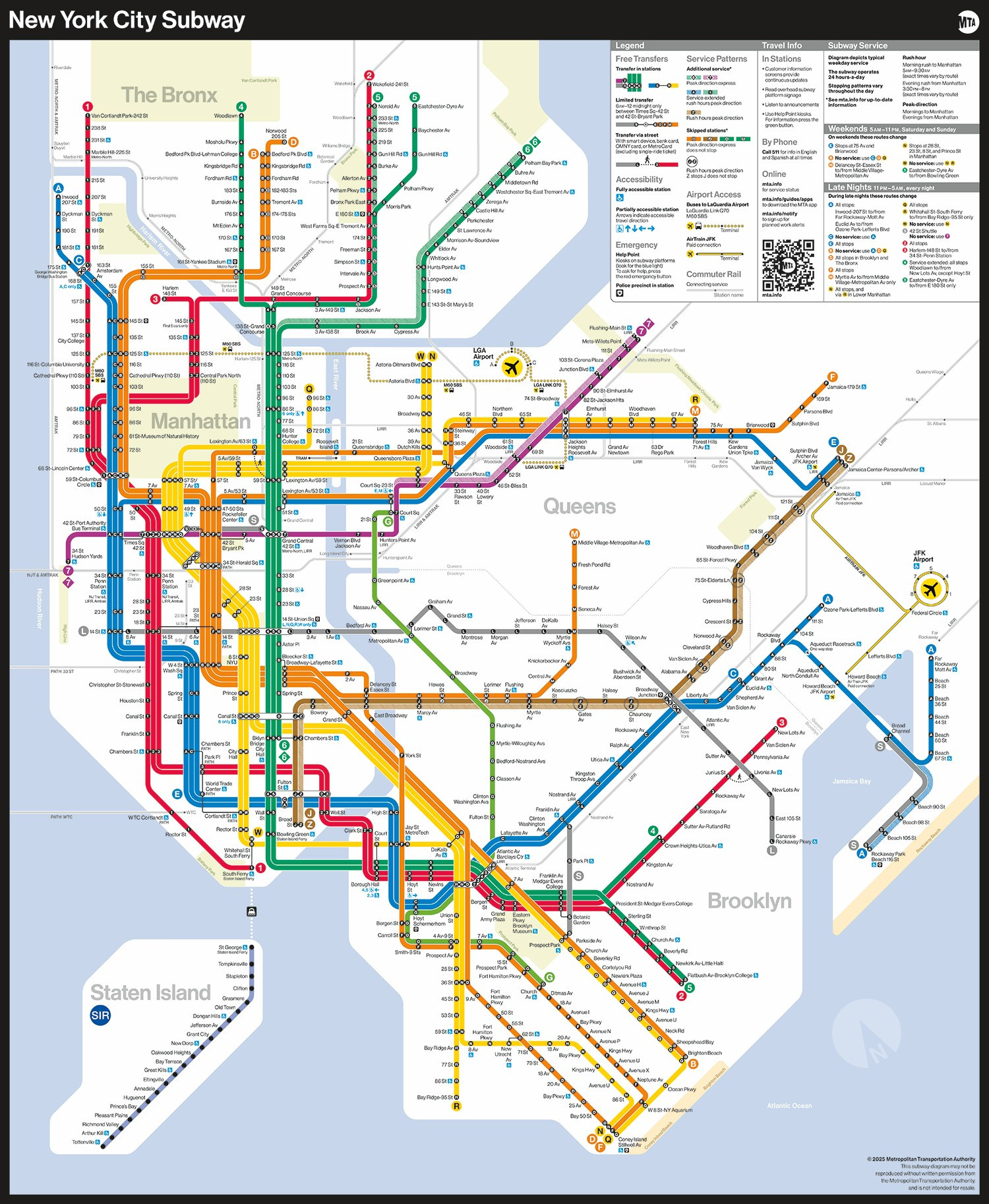
Say hello to a new subway map! 🗺️
Today, the MTA unveiled a new subway diagram that provides riders with essential travel information in an easily readable, bright, and orderly manner.
Today, the MTA unveiled a new subway diagram that provides riders with essential travel information in an easily readable, bright, and orderly manner.
Comments
Oh, you dear things...
Nice to see NYC is finally getting a fit-for-purpose transit map at last.
For actual navigation, everyone will just use Google Maps.
You did...a job. I guess.
If y’all can’t find yourself in a grid city with numbered streets then it seems more like an issue of skill ngl
You don’t need streets labeled on a service map
I remember in Prague how cold and rude it was, but here people constantly look at the map and ask questions to everyone around them on where landmarks are
Perfect compromise between readability and scale.
Sacrifices precision as well as streets and neighborhood names
You also lose all sense of actual distance. That's a very tough loss
The previous map -- imperfect -- but was rich with info and precision
Are paper copies available at token booths?
If you wanted a map of the New York city, streets, landmarks, neighborhoods, subway and a general Geo-locator… this ain’t it.
The map is so distorted, Central Park looks like it’s in Harlem.
Schematic maps are a thing in most other cities in the world and people understand that the maps are slightly distorted to be more legible.
Why follow on London’s mistake.
People sign the praises of that Harry Beck fellow but he was wrong.
They are both on the district line, are they not?
What is there on the map to tell me I can’t?
There are platform announcements as well as signage.
8 to 9 million people make it around London and get to their destination with ease.
The question was in response to the comment “only an (ableist slur) wouldn’t understand it”
How about a shout out for the original originator, Harry Beck?
Here's a look back at NYC subway maps of the past 👇
New York City Transit Authority/George Salomon, 1958
New York City Transit Authority, 1967
@nytransitmuseum.bsky.social
Michael Hertz Associates/“Cityana,” 1978
Metropolitan Transportation Authority/Michael Hertz Associates, 1979
@nytransitmuseum.bsky.social
And tell us: Which version of the map is your favorite?
instead of cubicles or lab space.
The 9179 one is interesting for keeping real distances. It's admittedly a trade that makes it harder to read in some ways, but it's also very informative and it's nice to have that integrated availability of other world navigation context.
But may the MTA still be going strong in a few kiloyears!